


This intense little loop packs quite a lot into a short ride, taking you up to the serenity of the high mountains and back down to the hustle of the seafront in just 30km.
Starting from Nice Riquier train station, head north onto the busy Boulevard de l’Armée des Alpes before turning right onto the improbably named Boulevard Bischoffsheim. Once you’ve got your tongue around the bizarre road names you can focus on pushing your way up the “warm-up” climb towards the observatoire.
Within 6km you’ll have gained your first col! The Col des Quatre Chemins, at the giddy altitude of 329m - I did mention that this is only the warm-up… The col sits at an intersection from where you can turn left, right or continue straight on. Carry on for just a few metres and take the next left after the derelict house to begin the climb up the ancient Roman road of Chemin de Lauze.
This is a quiet residential road lined with shady trees and overgrown flowers. The road surface is pretty good, only getting gravelly towards the top. The gradient quickly gets rather steep and the last few hundred yards over potholes and stones are a bit of a struggle (they were for me, anyway).
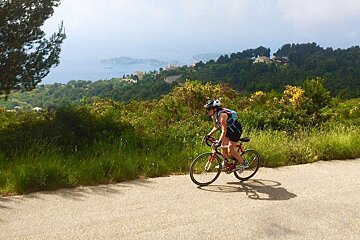
Once you get past the houses you’ll have reached the Plateau de la Justice, where the route flattens out into a beautiful mountain road with breathtaking views of the medieval village of Eze and the bay beyond. At least it would have done if we hadn’t been surrounded by cloud but we could see just enough to know that on a clear day this view is a stunner.
Cruising along this section is bliss; flowers everywhere, spectacular scenery, supersmooth asphalt and practically no traffic whatsoever. I imagine it may be a little busier during peak summer months (as well as blisteringly hot) but it will certainly be off the beaten track of most of the tourist traffic.
From here is it a pleasant descent back down to rejoin the Grande Corniche just in time to tick Col d’Eze off the list - which feels like a piece of cake compared to what you’ve just climbed. Take a left at the first road you come to on entering the village and start climbing again up Route de la Revere.
A steady incline brings you to the Parc Naturel Départemental de la Grande Corniche, a gorgeous scenic ride with some very hairy drops off the edge of the route - my other half was actually glad of the heavy cloud as it shielded him from the view of what the fall would be like if it all went wrong… The road through the park is asphalt and well-kept but some parts are a bit rough, so if you’ve pumped your tyres to the max you might want to walk some parts to avoid the possibility of a puncture. Some routes through the park (including the road that we took back down) may be closed at certain times of the year so check before you go, to avoid having to find another road.
The descent is, admittedly, a bit sketchy. You’ll come to a fork where the signs point to a hiking trail for La Turbie on the left or the D2564 on the right. Take the right turn down a narrow road, strewn with stones, tight bends and signs warning of potential rockfalls. It’s not nice but it doesn’t last long and then you’re on the civilised asphalt of the Grande Corniche once more. Head right towards Eze Village and look out for a left turn towards Villefranche-Sur-Mer, Eze-Sur-Mer and Beaulieu-Sur-Mer; if your translation skills are up to scratch then you’ll soon surmise that we are heading towards the sea.
A smooth descent brings you to the gaudy riot of pink and ochre that is Villefranche with it’s cascades of bougainvillea spilling over brightly coloured villas. From here it is an easy cruise, albeit weaving through the coastal traffic, along the coastline back to Nice via Boulevard Maeterlinck and past the rocky splendour of Coco Beach.
Distance: 30km
Elevation gain: 1025m
Highest point: 680m