


When Lance Armstrong describes a training route as “mythical” you know it’s not going to be easy…
The Col de la Madone is one of the most famous climbs in the Alpes-Maritimes, used as a benchmark for many Tour de France athletes as to how they would perform on the hardest stages of the tour. I’m not sure if this is supposed to motivate or scare you but I can confirm that you don’t need to be a world class cyclist to reach the famous summit!
There are a number of starting points but we set off from the seafront at Menton, turning north-west at the outdoor swimming pool and up Route de Gorbio. Start off by following signs to Gorbio through the town centre and then pick up signs for Sainte-Agnes as soon as you see them. Once you’re on the road to Sainte-Agnes you’ll see green and while cycling signs for the Col de la Madone.
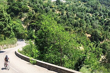
There is no easy warm-up on this ride, you start climbing straight away and you don’t stop until you reach the col. No flat or downhill bits to catch your breath, just up and up and up. Fortunately the scenery is stunning and the road surface is exceptionally good; there is also very little traffic other than fellow cyclists.
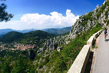
As the road winds round the mountains you get alternating views of the sea dropping away beneath you and the medieval village of Sainte-Agnes perched on a mountainside above you. This quirky little place holds the title of “highest coastal village in Europe” - it may be a few kms inland but it qualifies due to the fact that you can still see the sea from its elevated position at almost 800m.
On reaching Sainte-Agnes take a hard left and continue up in the direction of Peille. I was under the impression that we were nearly there by this point and started to congratulate myself on not finding it as hard as I expected. I breezed along the next stretch thinking that it was actually a bit of a cruise and we would probably see the col around the next bend.
However, this is the part when you have to remind yourself that there’s probably a reason why even Lance Armstrong says it’s quite hard. It suddenly gets really steep. And carries on being really steep. For quite a long time.
Another thing to mention about this route is that there is barely any shade the whole way, and it can get a bit sunny in the South of France. By this point I was wilting under the strong rays of the sun and the intense heat that was coming up off the asphalt and being radiated off the white limestone rocks that tower over one side of the road. Apparently the view from up here is absolutely marvellous but I couldn’t see an awful lot through my veil of sweat and tears.
Finally, we rounded the final bend and made it up to the col; a glorious wide open plateau with sweet cool breezes and majestic views of the mountain ranges disappearing into the distance. After a breather and a few photos we got back on our bikes and started the descent to Peille, never have I been so happy to be going downhill.
The descent to Peille is a delight, not only because it is not an ascent (unless you’re coming from the other direction obviously) but because of the fantastic views and colourful flora that line the road. This side of the col is far less steep than the other, making the ride down a pleasant freewheeling cruise that passes a number of small pretty villages. If you’re planning to stop en route then I recommend Peille, a labyrinth of narrow cobbled streets with lots of historic architecture and a friendly atmosphere.
After Peille you continue along the D21 past Cantaron and Drap, both nice towns if you want somewhere to stop for a quick break. Once you get past Drap you’ll notice the traffic becoming heavier and this culminates in the chaos that is La Trinité, getting busier and busier as you approach Nice. This route will bring you on to the Avenue Joseph Raybaud, from where you can choose whether to head back to where you started at Riquier or continue south to the seafront; there are a couple of intersections where you may find it safer to dismount and use the pedestrian crossings.
Distance: 45km
Elevation gain: 1600m
Highest point: 937m